Explore the capital with our interactive London map: discover the locations of iconic attractions and navigate between districts with ease. Plan your itinerary perfectly!
If you’re planning a trip to London, the interactive map on this page contains all the attractions of interest covered in our guide. Simply click on the markers on the map, or on the list just below, to access detailed information for each location.
Transport maps in PDF
Whether you’re planning to travel around London by Underground, bus, DLR, Overground or river services, you’ll find a free map for each transport mode to help you navigate the city quickly.
London Underground map
The London Underground map simplifies navigation of London’s underground railway network. This easy-to-use tube map shows all nine travel zones, including Zone 1, which covers central London. It also indicates step-free access stations, river ferry services, trams, airports and more. It’s the first map you should consult when planning a trip to London.
London’s bus network is extensive and highly comprehensive. This map shows only the main bus routes in central London and the night buses most commonly used by tourists.
The DLR is a fully automated elevated train serving key destinations such as Stratford (Westfield Shopping Centre), Canary Wharf and Cutty Sark, extending to Greenwich.
The London Overground forms a circle around the capital, with branches extending into outer areas. London Overground services pass through stations including Stratford, Euston, Shoreditch High Street, Hampstead Heath, Shepherd’s Bush and Kensington Olympia.
Discover all options for travelling on the River Thames. The main river service stops are Westminster (Houses of Parliament), London Eye, Embankment (West End), Tower (Tower of London) and Greenwich.
 Airport
 Stadium
 Attraction
 District
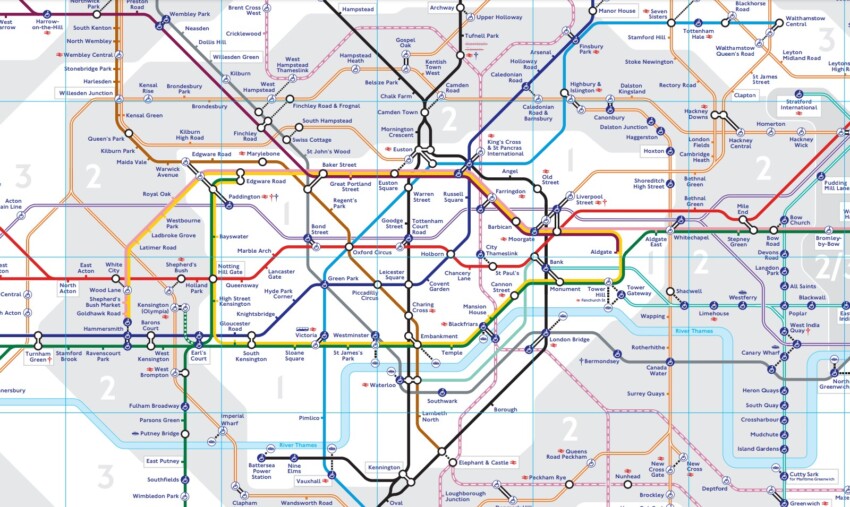

 Hotel
Hotel  Budget accommodations
  Apartments
  Family Hotel
  Luxury Hotel