Royal Hotel
Stornoway - Cromwell St
Book now

Looking at the photographs, if you find yourself wondering whether you’ve somehow ended up at the wrong latitude, rest assured – you haven’t landed in the Maldives, but at the Hebrides archipelago.
One of the wonders of this island group is undoubtedly the incredibly long stretches of fine white sand lapped by the crystal-clear waters of the ocean: on sunny days, you’ll find yourself convinced you’re in the Caribbean. You’ll be left absolutely speechless by the incredible colours that surround these lands: the white sand, the turquoise sea, the dazzling green of meadows that sweep down to the beach, the yellow and black of puffins, the purple of heather.
These 200 islands strung together in a line stretching 200 kilometres face the fury of the ocean every single day as it crashes against the treacherous rocks and imposing cliffs, punctuated by sheltered, sandy bays. Inland, meanwhile, is a succession of formidable mountain chains rising up against spectacular moorland and boggy peatlands dotted with tiny lochans – small lochs.
Like the Orkneys and Shetland, nature dominates over human presence here: these are lonely, remote lands home to just under 27,000 people, and you’ll drive for hours with only the nature surrounding you as company – so complete in its presence that at times you may even feel a sense of being lost.
Unlike the other islands off the coast of Scotland, there’s still a palpable sense of cultural isolation here: the economy of this Gaelic-speaking population isn’t built on tourism but on agriculture, fishing, shepherding and weaving.
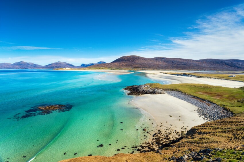
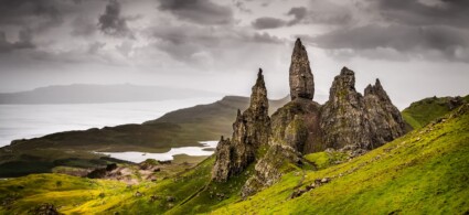
The region of Harris is truly spectacular: seductive hills, verdant slopes inhabited by puffins that sweep down towards bays with gleaming white sand and crystalline, turquoise waters that look like they’ve been plucked straight from a Caribbean postcard. This is an utterly remote corner of the ocean, and you’ll feel as though you’re the only inhabitants on earth!
Despite being called an island, Harris is merely a rocky outcrop of Lewis: the division exists only on maps and dates back to ancient feuds within the McLeod clan.
If you’re coming from Lewis, don’t miss the stretch of A859 towards Tarbert: it crosses North Harris, an area characterised by pyramidal peaks looming over the shores of Loch Shiphoirt, passing through a lunar landscape of boulders and rock.
Another absolutely magnificent scenic route is the B887, which crosses the Forest of Harris: it’s a bleak area, despite its name, and here the Norwegians established a whaling station, still visible today thanks to the loading slipways and red chimneys.
South Harris has less dramatic mountains but boasts the finest beaches in the entire archipelago: whilst the east coast is jagged and inhospitable, the west coast is a feast for the eyes. Here you’ll find dream beaches – magnificent stretches of white sand swept by the wind and caressed by crystal-clear sea in the most enchanting hues. We recommend taking your time: every cove, every bend brings a discovery, and don’t skip stops for the sake of pace – they’ll reward you with postcard-worthy landscapes!
If you have time, venture down the minor roads that’ll lead you to the waterline: it’s priceless to stop and walk barefoot across the white sand. Besides, these quiet lanes can, with a bit of luck, offer small delights – like meeting locals for a chat or watching sheep being sheared in the numerous enclosures dotting the area.
One of the most captivating beaches is undoubtedly the vast expanse of Tràigh Losgaintir: continuing on, though, you’ll encounter a succession of equally marvellous beaches surrounded by dunes and machair, a rich coastal grassland used for grazing and covered in flowers during the warmer months.
When you reach the tip of Harris at Roghadal, it’ll feel as though you’ve reached the end of the world: from here on, moving to the island’s eastern side, the landscape transforms completely: sand gives way to rock, green to grey, gentleness to harshness. The desolation and sense of isolation combined with the tortuous and lengthy nature of the road may leave you feeling uneasy and alone. But this too is one of the faces of the Outer Hebrides.
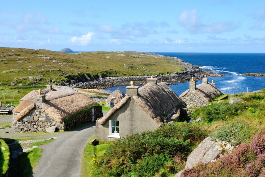
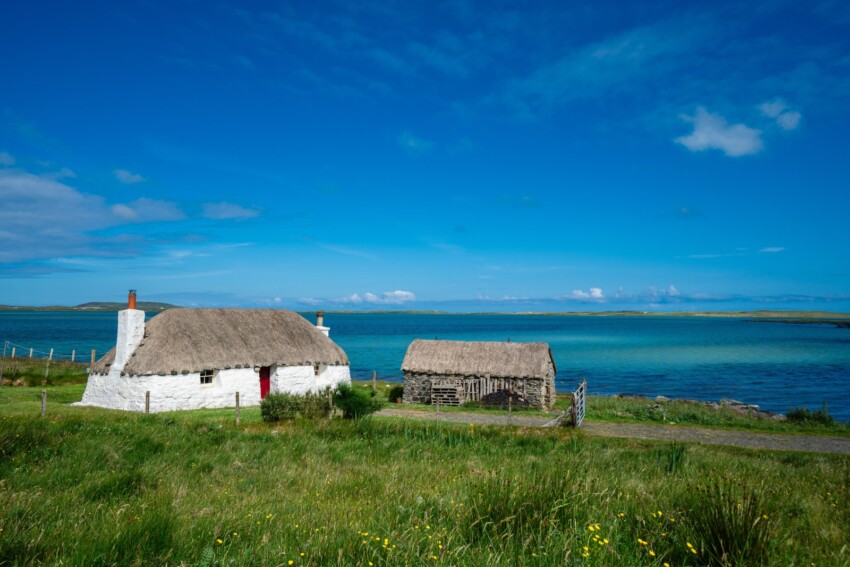
To reach this remote village, you’ll traverse lonely moorland characterised by a succession of peatlands dotted with the ruins of blackhouses, the typical traditional cottages of local farmers.
It’s precisely a village of blackhouses that makes up the coastal settlement of Gearrannan, which overlooks the ocean: a series of traditional farmhouses (the last was abandoned in 1974) have been restored and give visitors insight into the poverty and simplicity of life in these incredibly remote lands.
This village also offers a blackhouse functioning as a hostel where you can stay, while others have been converted into self-catering holiday cottages. For more information: www.gatliff.org.uk
We should mention that on Sundays the Hebrides are strictly closed: the site is accessible only from the outside, and we’d recommend bringing packed lunch as you’ll struggle to find anywhere open for food nearby.
Just before arriving here, make a brief stop at Bragar: in this tiny village, you’ll see an authentic arch formed by the jawbone of a blue whale that beached here in 1920.
Just metres from Gearrannan stands the Dù Charlabhaigh Broch, Scotland’s largest drystone-built fortified tower, positioned on a rocky outcrop above the sea.
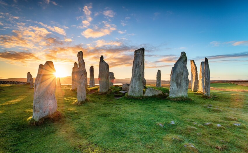
The Callanish stone circle is one of the most spectacular archaeological sites on the Hebrides.
Roughly fifty menhirs arranged in a circle, some standing up to 4.5 metres tall, will leave you absolutely breathless – especially if you’re fortunate enough to admire them at sunset on a fine, sunny day, when they’ll reveal all their ancient and mysterious allure.
Scholars continue to puzzle over the origins and purpose of this Neolithic stone circle: the most likely theory involves an astronomical use connected to predicting the seasonal cycle. Indeed, the stones are aligned with the positions of the sun and stars, and agriculture was the primary activity of human settlements in this area.
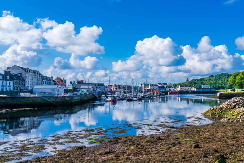
After the ferry crossing to reach the Hebrides, arriving in Stornoway feels like reaching somewhere completely out of the ordinary.
This small town on the island of Lewis is a frontier place – a home to fishermen, travellers arriving cold and disoriented, surrounded by sea and moorland.
Beyond the harbour and tiny town centre, this place doesn’t have much to offer, but for virtually all visitors it’s an obligatory transit point for beginning your exploration of the islands: the heart of town is the pedestrianised Francis Street, where the few pubs and restaurants are concentrated.
To the north-west of the centre stands Lews Castle, a symbol of the ancient oppression by the English, who evicted the small farmers of the area.
Not to be missed is the splendid Hebridean Celtic Festival, which takes place here every July – for details, visit www.hebceltfest.com.
Even if you’re travelling in the height of summer, we’d recommend booking your accommodation in advance: on the islands, lodging options are limited and particularly scarce in the most isolated areas.
The landscapes and panoramas of the island of Uist are very similar to those of Harris and Lewis: white beaches fringed with glorious machair (grassy lands used for grazing), the most enchanting in the region thanks to the spectacular flower-filled meadows, tall peaks dotted with a labyrinth of lovely lochs.
The major difference from its twin islands Harris and Lewis perhaps lies in the isolation: very few tourists make it here, and most are interested in salmon and trout fishing or birdwatching. This makes this remote island feel all the more authentic.
There are several archaeological sites worth visiting: Barpa Langais, an enormous cairn with a burial chamber, the stone circle of Pobull Fhinn, in a very picturesque location, and Na Fir Bhreige – three menhirs that, according to legend, were turned to stone by a witch.
For beach exploration, we recommend following the minor roads and passing through the small farming villages – the only true way to fully experience this magnificent island.
In the following map you can see the location of the main places of interest mentioned in this article.
The company Caledonian MacBrayne has a monopoly on the routes connecting Scotland to the Hebrides archipelago and the western islands – namely Islay, Jura, Skye, Arran – as well as smaller islands including Rum, Mull, Staffa and many others, covering a total of 22 islands and four peninsulas.
On certain routes between mid-April and mid-May, Sunday services are suspended, with the exception of Easter Sunday: it’s always best to check in advance.
 Hotel
Hotel  Budget accommodations
  Apartments
  Family Hotel
  Luxury Hotel